Workflow
FlightEye integrates the Raspberry Pi IV and Microsoft HoloLens2 to create an easy-to-use and robust system
-

Acquiring ADS-B
ADS-B data is the backbone of FlightEye, as it allows us to be aware of aircraft around us. On average, every second aircraft broadcast ADS-B data, showing their position, speed, altitude, etc. Using the Raspberry Pi, we gather this data and convert it to JSON.
-

Network Connection
After generating ADS-B data in JSON format, FlightEye uses a private WiFi connection to send JSON data from the Raspberry Pi to the HoloLens 2. As long as the Raspberry Pi is powered on and the HoloLens 2 is connected to the Pi's network, data transmission will begin.
-
Predictive Algorithm
Our predictive algorithm uses linear-quadratic estimation to determine the approximate location of each nearby aircraft in between ADS-B transmissions. The algorithm is a derivation of the Kalman Filter, designed to sustain the computational intensity of real-time augmented reality systems. When activated, the UI markers will move smoothly across the viewport, modeling the instantaneous predicted location of an aircraft until a new ADS-B frame is received.
-
UI Placement
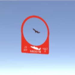
Once all of the aircraft data is updated, we are ready to render the marker for each aircraft within the headset. Our rendering algorithm allows for exactly 500ft of error in all directions, which consequently makes closer aircraft appear larger perspectively. Additionally, an aircraft icon is displayed on the marker which models the exact 6DOF position of the aircraft in space, and this allows the pilot to perform a quick evaluation of each aircraft's orientation. For those who require more precise information, the numerical data corresponding to each aircraft is displayed alongside the icon.
UI Design
A UI designed by pilots, for pilots.
Aircraft Icon
Using the relative orientation to the pilot, FlightEye can show which direction the aircraft is heading by moving the aircraft icon.
Dynamic Sizing
Depending on how far away the aircraft is, the UI will increase or decrease its size to bring attention to closer aircraft.
Aircraft Information
Airspeed, relative elevation difference, heading, distance, and tail number are all prominently shown for each aircraft.
FlightEye Menu
At the tip of your finger, each pilot has immediate control of all FlightEye systems.
Hand Controls
By a simple extension of the left arm, the FlightEye Menu will appear. No need for physical buttons or complex menus, everything is avaliable at once.
Compass Calibration
In order to calibrate the FlightEye systems, users must enter their heading at startup. After pressing the calibrate button, users are directed to enter their heading.
Buttons and Sliders
Using the buttons and sliders, users can control the filter range, UI brightness, toggle UI, toggle the predictive algorithm, reconnect to the Pi, or ping the Pi.
Tools and Technology
FlightEye covers a wide array of the technology stack, ranging from low-level hexidemical decoding, to high-level gaming engines.
Unity
Unity is the primary development enviornment for deploying software on the Microsoft HoloLens. The platform allows us to generate renderings that correlate directly with our geospatial orientation.
Hardware and Accessories
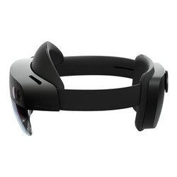
FlightEye makes use of two seperate components: our custom ADS-B enclosure (code named ADS-Box) and the Microsoft HoloLens 2. The ADS-B enclosure is comprised of a 1090MHz antenna, GPS dongle, and a Raspberry Pi. The enclosure gathers all relevant data for nearby aircraft and user position and sends it wirelessly to the HoloLens 2 via a WiFi network hosted on the Raspberry Pi.
Microsoft MRKT
MRKT provides us with the ability to interact with tracking and sensing within the Microsoft HoloLens. In our project, MRTK allows us to generate hand menus, utilize eye tracking, and build our project for deployment.
dump1090
In order to receive and decode ADS-B transmissions, FlightEye uses an industry standard, open-source, program called dump1090. This program runs on the Raspberry Pi and configures the gain of the 1090MHz antenna, and decodes the incoming ADS-B packets. dump1090 then outputs the decoded packets into a simple JSON file, which is sent to the HoloLens 2 so it can be displayed.
